Payerne Hospital - 3D Scan for an Extension Project

A hospital extension project

How to perform a complete 3D survey of a hospital while minimizing the disturbance caused by it?
As part of a project to extend the International Hospital in La Broye, we intervened to carry out a 3D survey of the interior and exterior of the building.
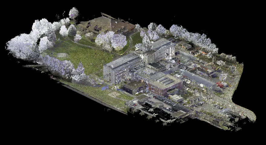
In total, a surface of 18,000 m² was the subject of the survey, which was completed in only 4 days.
Hospital survey operations require a specific organization in order to adapt to the functioning of the establishment. Consultation rooms, intensive care units, ER, operating theatres: the functioning of a large number of areas should not be disrupted.
In order to adapt to the specificities of the building and to minimize the disruption of our intervention, we combined static and mobile scanning solutions.
A 3D survey combining static and mobile scanners
The 3D survey with a static scanner
Survey of the exterior of the building
The entire exterior of the building was measured using a static scanner. Leica RTC360.Initially, it was the facades that were raised with a static scanner: given their height, a 3D survey with a mobile scanner was not possible.
The roof of the building was then raised using a static scanner. Since it was accessible and secure, it was possible for an operator to access it and digitize the environment. Some stations had a point of view towards the targets placed around the building, thus promoting the alignment of all the outdoor stations (facades and roof). By covering the entire exterior with a static scanner, we were able to limit ourselves to two survey solutions, by eliminating the need for drone capture for areas at height.
Scanning congested areas
Then, the most difficult to access and congested parts were identified with the static scanner. Several types of rooms were concerned, such as certain boiler rooms and technical rooms, roof accesses and multiple stairwells.
In addition, in order to constitute a “skeleton” of the building, we sealed the three stairwells of the main building with a static scanner. This skeleton was then the base for connecting the other point clouds captured with the mobile scanner. In this way, the risks of excesses are drastically reduced. At the same time, in order to promote the alignment of all point clouds, targets and stickers were placed, both indoors and outdoors.
Using a mobile scanner
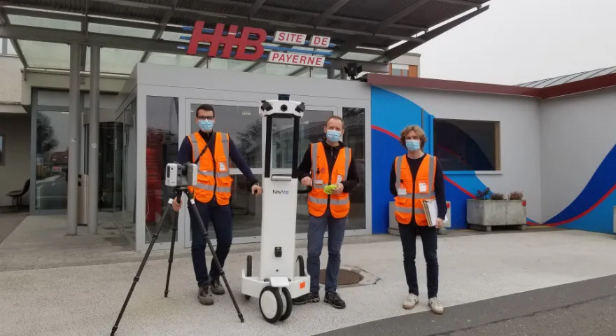
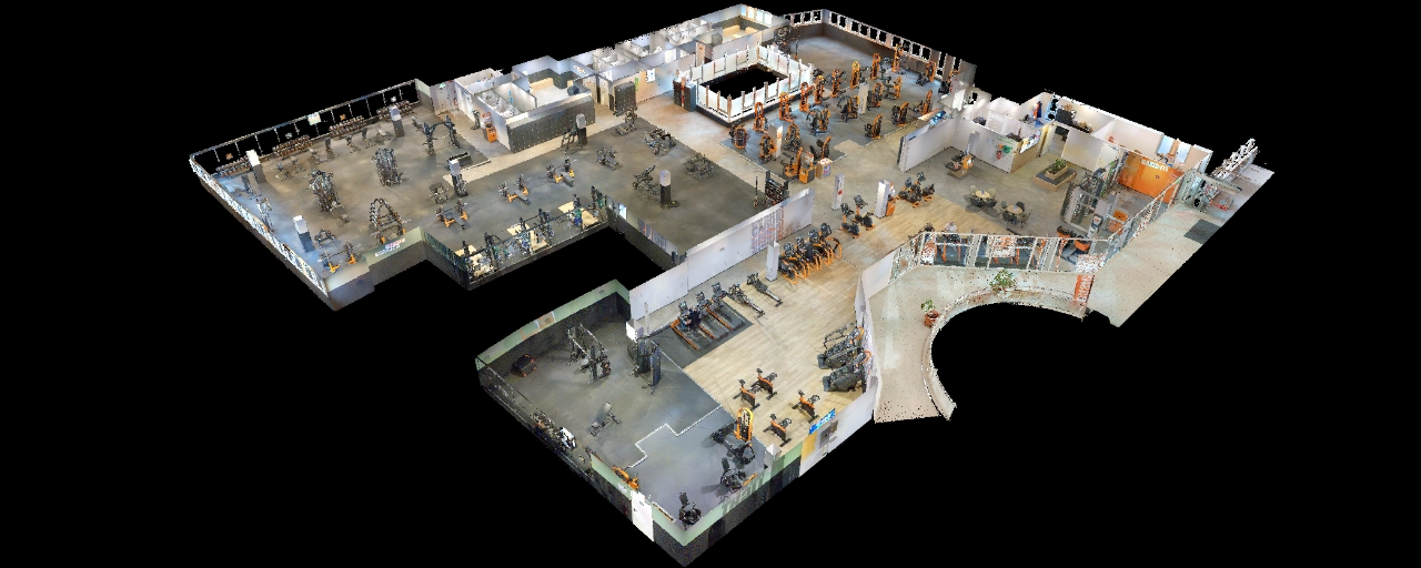
In addition to the static scanner survey, all the most accessible areas of the building (corridors, medical services, operator blocks, common areas of the hospital, etc.) were recorded with the NavVis M6 mobile scanner.
When it comes to a hospital, and in particular sensitive environments such as intensive care or emergency services, the speed of capture becomes crucial. A solution like the NavVis M6 is therefore very relevant, since it allows us to minimize the intervention time in each zone. Thus, we were able to raise all the services (intensive care, emergency, operating rooms) by carrying out a simple loop within them, at the best time for the hospital staff.
This capture method was largely preferred to the static scanner, which involves multiplying the stations for each service, and therefore spending more time there.

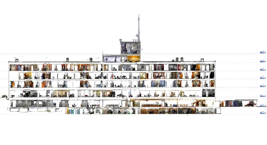
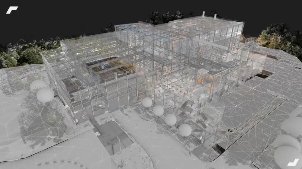
A complete point cloud for a BIM modeling project
The assembled point cloud was delivered to an AMO agency in order to conduct the BIM modeling. As examples of use, below is a section in the building's point cloud. This will have been used on the one hand to verify the quality of the point cloud, but also to define the levels of the building during the modeling phase.
The model will then be delivered to the architecture agency in charge of the project, which will use it as a support to evolve into the design model of the new project.
Let's study your project together
Contact us, we will study your project to provide you with an estimate as soon as possible
Contact us


To make sure you don't miss out on our news, subscribe to our newsletter now!
Receive quarterly updates directly in your inbox to stay informed about the latest news and events at My Digital Buildings.


