3D scan and modeling of an energy recovery unit following the renewal of a DSP

As part of the renewal of the DSP, we assisted the SMPRB in conducting an inventory of the TADEN UVE by producing 2D plans, 3D models, and virtual visits. Discover the benefits of this innovative approach.
As part of the renewal of its Public Services Delegation (DSP), the SMPRB (Syndicat Mixte de Valuation de Décretes des Pays de Rance et de la Baie), owner of the Energy Recovery Unit (UVE) in Taden, wanted to offer an exhaustive vision of its site to candidates. The objective was to enable them to develop a qualitative application and to project themselves as best as possible into the future management of the premises.
To do this, the syndicate has given us the mission of fixing the condition of the building via 3D scanning. The main objective was to produce, from a single survey, several essential deliverables:
- One 3D mockup detailed.
- One virtual tour immersive.
- Of 2D plans updated.
This survey operation was carried out in a complex technical environment, including numerous footbridges and high-temperature areas. Knowledge of this very specific context was crucial for the successful implementation of the project.

A multi-technology 3D survey strategy
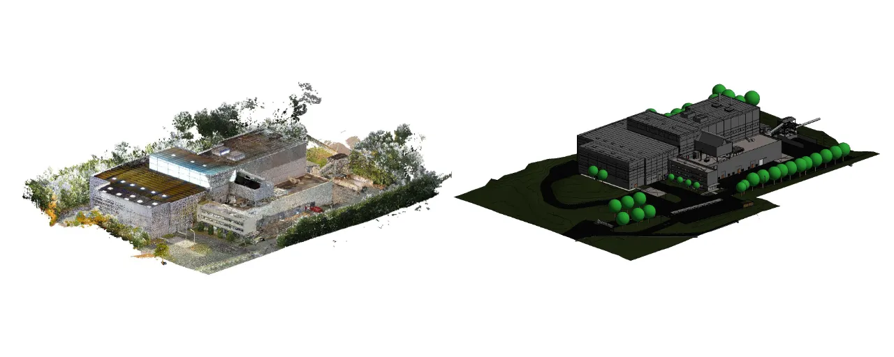
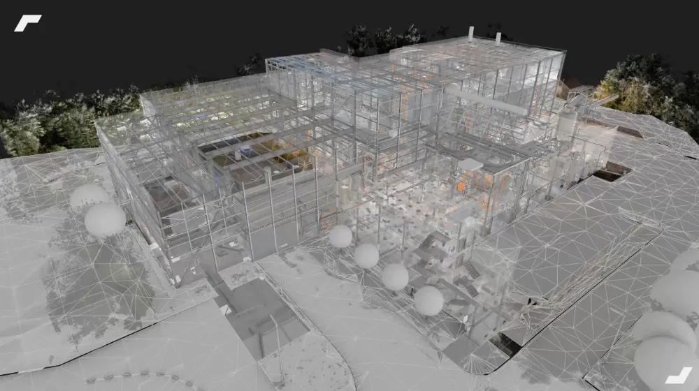
To cover the entire UVE, a tailor-made 3D survey protocol has been put in place, combining three complementary technologies: NavVis VLX mobile scanner, the Leica RTC360 static scanner, and a drone.
The NavVis VLX scanner was used to scan large areas, which were characterized by standard ceiling heights. It is important to note that it also made it possible to identify a multitude of process equipment located at height. While this type of survey is usually done with a static scanner on a tripod, the presence of numerous footbridges on the site allowed an operator to use the dynamic scanner to capture all this equipment, while in motion.
At the same time, the static scanner made it possible to cover more technical and cramped areas, guaranteeing increased precision where needed. Finally, the drone carried out a photogrammetric survey of inaccessible outdoor areas, such as roofs.
This multi-technological approach ensured a complete survey of the site, including in its most complex areas.

Complementary deliverables for a complete vision
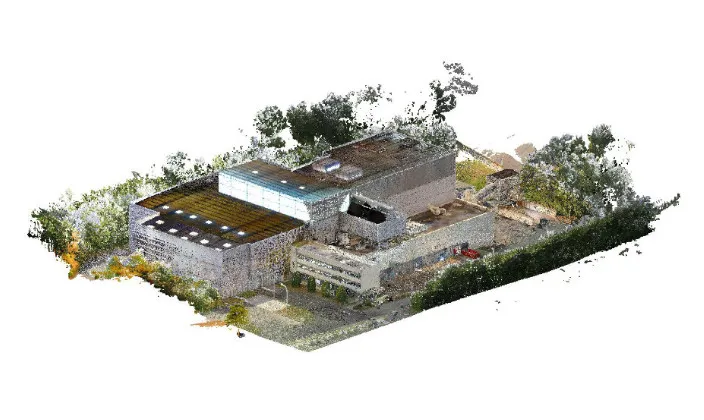
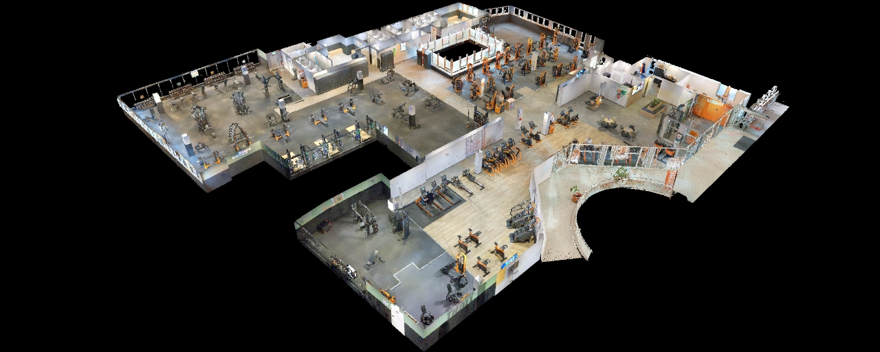
From the 3D survey, a point cloud representative of the building has been assembled. This point cloud was then used as a basis for producing a 3D digital model as well as 2D plans (sections and elevations).
The digital model was modelled according to different levels of detail (LOD) to optimize its use:
- The lots ECA, Structure and Networks (SSI, Plumbing, HVAC) were modeled at LOD 300. This higher level of detail was used for critical technical elements and those that could be simulated.
- The lots Electricity and the external elements of the site were modelled at LOD 200.
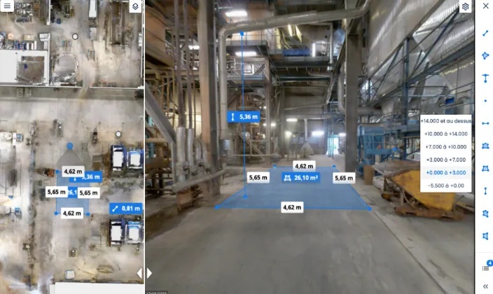
At the same time, a virtual tour of the site has been deployed. Based on panoramic images and the 3D point cloud captured by the NavVis VLX scanner, it offers users a capability to take measurements directly in a precise visual environment.
In the end, these three deliverables demonstrated a strong complementarity. Thanks to their varied modes of representation, they offer future DSP candidates a complete understanding of the site and its infrastructures.

Results and use of deliverables
The current use of deliverables
The three additional deliverables have been made available to all candidates for renewal of the DSP. For their part, the digital mockup And the 2D plans were quickly adopted by the candidates. These tools allowed them to conduct layout simulations and to project their future operation of the plant with precision.

Thanks to these materials, the applications received were of a high quality. The technical projections were well constructed and the foresight of future tools and structures was particularly refined.
Finally, the virtual tour proved to be a tool of choice in addition to physical visits to the site. It allowed businesses to view a photorealistic environment at any time. from a web interface, thus facilitating the construction of their offers.
It should be noted that this visual representation of the site not only provided respondents with an overview, playing on the quality of their file, but also made it possible to reduce the number of visits to the site, making it possible to generate considerable time savings for all project stakeholders.
Future uses already anticipated
While the renewal of the DSP will be implemented in 2023, those responsible for the consultation are already anticipating new uses for the digital model, on two main axes:
- Management and maintenance : Use the model in a CMMS logic (Computer-Assisted Maintenance Management) to monitor the maintenance of the recovery center in a more computerized and spatial manner.
- Control and evolution : Consider a second digitization and modeling of the UVE in the coming years. The objective is to compare the operational projection of the new operator with reality, and to monitor the precise evolution of the building year after year.
This operation was a success as part of the renewal of the DSP. We are already imagining new uses around the model, concerning maintenance and monitoring the evolution of the site in operation.
Let's study your project together
Contact us, we will study your project to provide you with an estimate as soon as possible
Contact us


To make sure you don't miss out on our news, subscribe to our newsletter now!
Receive quarterly updates directly in your inbox to stay informed about the latest news and events at My Digital Buildings.


