3D Aftermath Scan: The Fire of Louhans

In this case study of a housing disaster in Louhans, explore how a 3D survey of the building enabled stakeholders to more accurately assess the damage, and to remotely inspect the site throughout the project.
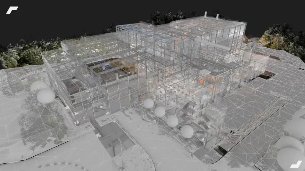
A 3D survey for the restoration of damaged buildings
Following a major fire that affected a housing complex in Louhans, the insurance expertise group Stelliant asked us to deal with the complexity of the disaster site.
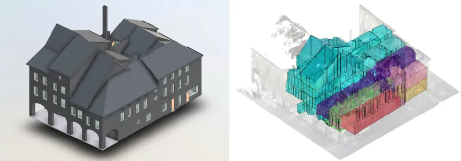
Composed of several interlocking buildings, levels and half-levels, the site was so complex that a precise overview was essential before launching any study project. Indeed, an error in diagnosis or interpretation would have endangered all the restoration work.
In this context, the 3D survey was established as a key step. It made it possible to provide a reliable solution, essential to guarantee the smooth running of the project and the coordination of the many actors involved. To digitize the entire site and respond to the urgency of the situation, the 3D survey operation was carried out in A single day, thanks to the use of two complementary technologies.
One Leica RTC360 static scanner has been deployed to capture the entire interior of buildings, even in the most congested and hard-to-reach areas. In parallel, a drone carried out a photogrammetric survey of inaccessible areas such as roofs, using aerial photos. This configuration made it possible to generate two essential deliverables:
- One 3D point cloud comprehensive overview of the buildings, which served as a basis for the production of up-to-date 2D plans and a digital model.
- A set of aerial photos which, after treatment, offered a photogrammetric rendering of the site, essential for visualizing the areas at height.
This combined approach made it possible to accurately freeze the situation in a minimum amount of time, a crucial step for the rest of the project.

Digital access to buildings
While insurance experts usually take a multitude of photos of their claims projects, it is the digitization of Louhans buildings that allowed them to freeze to archive the condition of the building following the fire. To remotely inspect the site, the point cloud, the virtual tour of the building and the photogrammetric rendering were very complementary supports.
These digital replicas of the buildings offered renderings equivalent to a field visit, available at any time on their computer. This continuity and permanence of the visuals were highly appreciated by the actors of the project. Compared to the few photos of the site that would have been taken without a 3D scan operation, the comprehensiveness of the information is much greater.
As Mr. Rousselot, the insurance expert of the Stelliant Group, tells us, “the 3D scan is a factor that multiplies the information from the field by 100, it assures us that we obtain an exhaustive survey where no area is missing, even the roof”.
A single digitization, complementary deliverables
The point cloud to inspect the building in its details
First, the point cloud was adapted to the inspection of the premises and the search for details. This 3D environment and the freedom of navigation offered made it possible in particular “to quickly interpret the disorders and to visualize what was behind each wall”, as Mr. Bonnavent, structural engineer on the project, tells us.
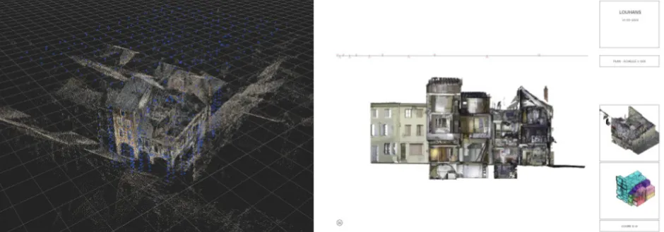
Sections can also be made in this point cloud, to generate vertical and horizontal orthophotos of buildings. These were particularly useful for this project since they allowed the structural design office “to identify wall deformations to measure the damage and impacts of the disaster”.
The virtual visit
In addition to the 3D renderings, the panoramic photos generated by our scanners made it possible to deploy a virtual tour of the site. In addition to allowing buildings to be inspected remotely via its “Google StreetView” navigation, it also allowed the project actors to take measurements (dimensions and surfaces) directly from this photorealistic environment. In particular, this feature will have helped project actors to make their decisions, calculations and studies more reliable.
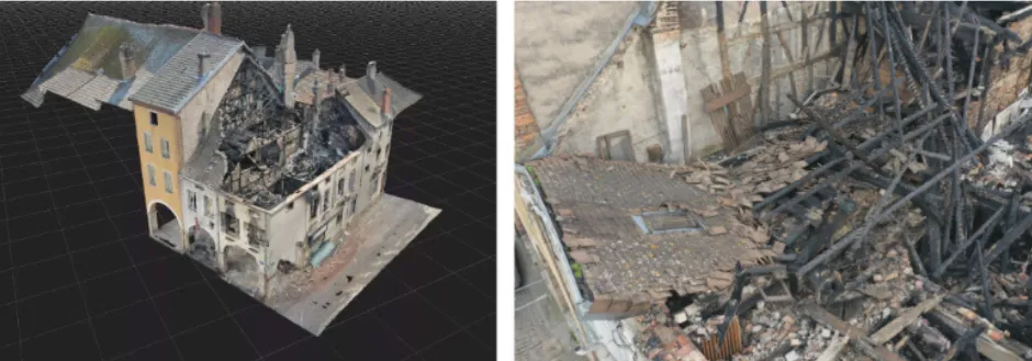
Photogrammetric rendering and detailed aerial inspection.
At the same time, photogrammetric rendering was used to inspect the damage caused to the roofs and high points of the building. Accompanied by the raw shots taken by the drone, these two references gave an overview of the Louhans site to all the actors of the project.
Since these materials were delivered in a few days, they quickly benefited all the actors appointed by the insurance expert. For example, the design offices were able to anticipate securing the site for their visit and improve their costing method.
Precise supports for estimating damage.
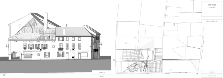
To simplify and speed up the damage estimate, the various actors in the project were able to exploit the 2D plans and the 3D model that were produced based on the 3D point cloud. This drawing process was very fast and accurate, especially compared to traditional 2D plan drawings that are based on a telemeter survey.
The latter are much more tedious and the risk of error they involve is too great for a project of the complexity of Louhans's. On the one hand, the 2D interior and exterior plans will have allowed the design offices to accurately estimate surfaces and to calculate the rows of materials to be removed.
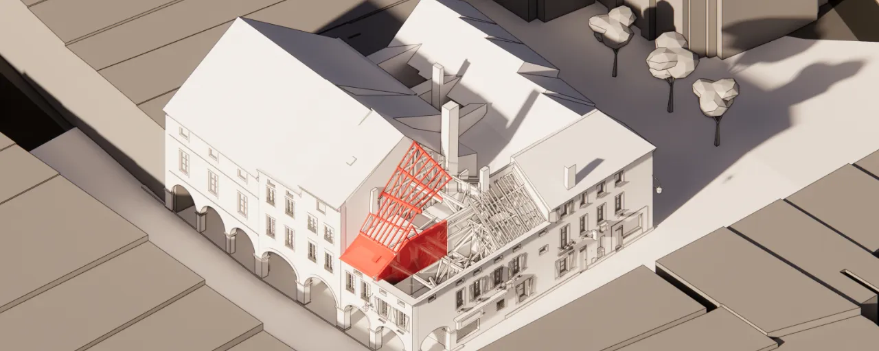
On the other hand, volume estimates and the identification of asbestos pipes will have been carried out in the 3D digital model of the site.
A mission report and illustrated exchanges
The Louhans project involved a large number of actors and exchanges. Whether on the side of assessing the damage between insurance experts, policyholders, and victims, or on the side of studies (structural design office, diagnosticist, architect).
These actors were able to benefit from common frameworks around which to collaborate productively. Like the long meetings where each actor returns to the building in turn, everyone was able to access digital buildings to carry out their inspections and studies in a secure manner.
Visually, the 3D views and sections produced allowed all stakeholders to realize the extent of the damage, in particular by clearly identifying elements such as wall deformations and the risk of collapse. Visuals from various media were able to feed into the mission reports and clearly illustrate the disaster.

3D scanning is an initial investment, which opens up to multiple uses (detecting the causes of claims, estimating damage, securing visits) to save a significant amount of time, particularly on complicated cases.
Let's study your project together
Contact us, we will study your project to provide you with an estimate as soon as possible
Contact us


To make sure you don't miss out on our news, subscribe to our newsletter now!
Receive quarterly updates directly in your inbox to stay informed about the latest news and events at My Digital Buildings.


